
Origin and geology of the island
Article Index
A) The tradition
B) The geology of the area
C) The alluvial theory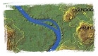
D) The islet and other hypothesis
E) The tufaceous hypothesis
F) Bibliography and Contributions
A) THE TRADITION
According to the legend reported in the literary sources (Dionysus Halicarnassus 5.13.2-4; Livius 2.5.1 [*] - 4; Plutarch Publ. 8.1-8 [*]) the island was generated by the progressive sedimentation of various materials and mud on the harvest of the Tarquini, reaped by Roman people in Campo Marzio and thrown down into Tiber river as considered impure after Tarquinio il Superbo was expelled from Rome in the summer of 509 b.C. (245 a.U.c.) when the low river level made easy their run aground.
The event, as recounted by Livius, was reconsidered around 1450 by Flavio Biondo as follows [1*]:
Il Campo Martio ci tira a dire de' duoi luoghi, cioè de l'Equiria, e de l'isola di Giove: ma del primo ci induggiaremo a dirne con gli spettacoli publici, de l'isola dice Livio, che essendo nel Campo Martio mature le biade di Tarquinio già cacciato di Roma, e reputandosi quel frutto irreligioso, ferono i Romani mieterle, e buttarle nel fiume che gli era presso; ma perciò che il Tevere a quel tempo correa molto piano, come suol di estate fare, quelli fasci di biade si fermorono in quella seccaggine, e limacci, dove poi cumulandovisi anco de le altre cose che suole il fiume sempre portare in giù, venne a poco a poco a farvisi una isoletta; e crede, che doppo anco si ci volgesse l'industria de gli huomini a farla più stabile, con buttarvi d'altre cose più gravi, e più ferme, onde havesse possuto esser bastante a sostenere i tempij, e gli portichi che vi furon fatti.
The late temporal placing of the origin of the island, as passed on by historians (even 245 years after the Rome foundation), caused many scholars to suppose the island was really a private property of Tarquini and that only after their expulsion from the town the island should return to the people. According to some scholars the legend of the harvest thrown down into the river should indicate that the island was really the Tarquini's granary.
B) THE GEOLOGY OF THE AREA
The last glaciation (Wurm), begun approximately 120.000 years ago, ended about 18.000 years ago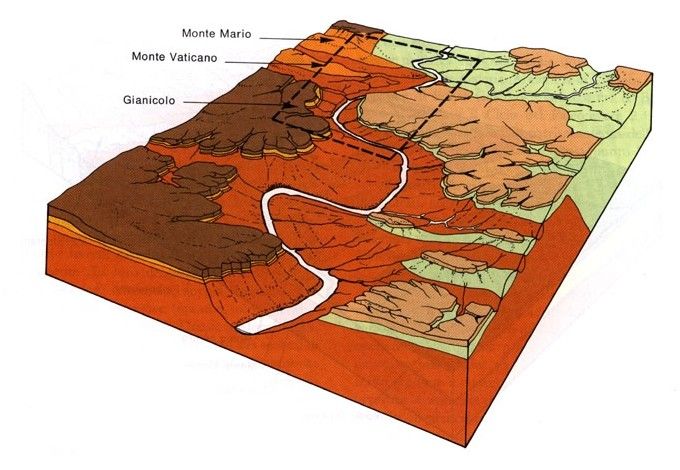 with a cold peak that produced a lowering of the sea level of 120 meters below the present one. This caused a strong cut of the Tiber valley: in particular in the Rome area the Tiber cut the compact substrate of the Pliocene clays (from 7 to 1.8 million years ago) up to about 50 m below the present sea level (pict. B1 [3]); consequently also the right and left tributaries dug deep and narrow valleys.
The following Post Pliocene raising (mainly on the right bank) and the consequent exposure to the erosion, brought about to receive the drifts produced by the next activity of Latium volcanoes.
A further raising of the ground helped the erosive action of the water streams, the Tiber and the tributary "marrane": the plain the valleys were therefore filled with Holocene drifts (10.000 years ago) and more recently with the accumulation of anthropic materials produced from the building activities in Rome.
On the right side two deep cut crossed the ridge Monte Mario-Janiculum delimiting the Vatican Hill; on the left side numerous cuts began to delineate the “hills” while one more reached the valley that would have become the marshy area of the Velabro, reaching the Tiber river near 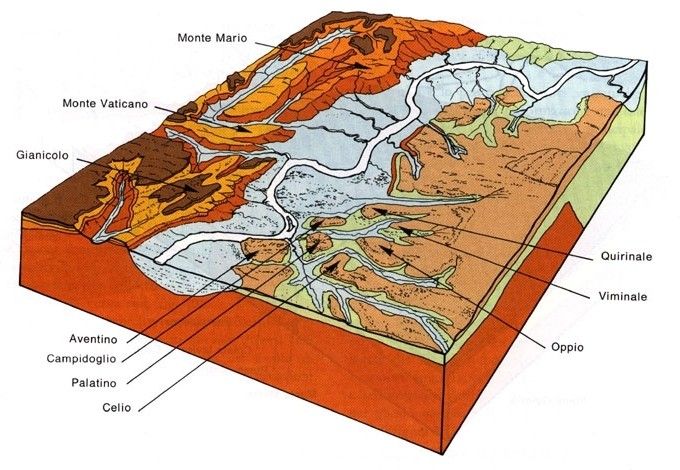 the present Tiber Island.
The Tiber flowed therefore embedded in a flat bottom valley with alluvial drifts. But after the Wurmian cold peak the sea level began to rise due to the fast increase of the temperature: this caused the progressive rise of the Tiber riverbed and its filling with alluvial Holocene drifts mainly centered in the Tiber valley (pict. B2 [3] the represented area corresponds to the outlined one in pict. B1).
C) THE ALLUVIAL THEORY
All the theories supported by the main geologists agree that either the geologic constitution of the island and its location induce to maintain it is constituted from geologically recent alluvial drifts; this would give also some scientific validity to what passed on by tradition.
As a result of deepened bibliographical searches and analysis of the surveys available in that time Gioacchino De Angelis d'Ossat [4] (1865-1957) (that, however, was not able to obtain the authorizations to execute further specific surveys, neither to examine the geognostic data collected for the impressive restoration works of the Fatebenefratelli hospital in 1934 by Bazzani, for whose foundations approximately 800 concrete piles were used), confirmed the alluvial origin of the island; such thesis is supported also by altimetry of the island, equal or slightly lower than the banks, and by the sandy characteristic of the banks themselves (Arenula)
Also the results of the deep drillings known in that time confirm the underground presence of layers of loose materials: fluvial drifts in the upper part and fluvial-lacustrine one in depths.
The most important boring was carried out below the small central barrel-vault of the Fabricio bridge across the foundation pillar up to a depth of 35.90 mt. The examination of the 31 samples, together with those relevant to two smaller boring (10.15 and 15 mt.) executed upstream and downstream the bridge, was carried out by Clerici in 1911 [6].
The survey produced the following results (the elevations are referred to the "zero level" at Ripetta):
- from mt. 9.50 to 0.5 drilling of the bridge pillar (below the central barrel-vault)
- from mt. 0.50 to –16.50 "sabbie sciolte ed elementi di varia grossezza" [loose sands and elements of various dimensions] up to small gravel
- from mt. –16,50 to –26.40 layers of clayey sands, clays and marls


Therefore all the found materials are loose and alluvial.
The pict. C1 [3] shows the schematic geologic section from the Capitol to the Janiculum through the Tiber island; the Clerici's survey is indicated in correspondence to the middle of the left branch.
D) THE ISLET AND OTHER HYPOTHESIS
The shape of the island changed during the centuries as noticed in the ancient maps of Rome.  In particular, as indicated in the map of Chiesa-Gambarini (1744) (pict.D1) and of Nolli (1748) (pict.D2), a smaller island, the "isolotto" [islet], was located between the Tiber island and the sandy left bank, from this named Arenula (or la Regola) [from the Italian rena=sand]. It is said it consisted of a big stone made up
  of fragments of basaltic lava strongly cemented together. This brought to thing that the islet was "...il residuo dell'argine fabbricato da Tarquinius Priscus, rassodato da Augusto e di bel nuovo racconciato da Aureliano a fine di reprimere l'urto del Tevere..." [...the remaining of the bank manufactured by Tarquinius Priscus, consolidated by Augustus and settled again by Aurelianus in order to sustain the push of the Tiber...].
The islet rejoined to the sandy left bank during the 1788 flood (in the area just called La Regola or Arenula). These are the words of Brocchi [7]:
«Nel 1788 gonfiato il Tevere ... le acque del fiume si avviarono precipitosamente alla foce. Nell'impeto del loro corso trassero giù dalla scoscesa ripa del monte de' Cenci gran copia di arena e rimase così intieramente ostruito un canale che da parecchi anni innanzi era già mezzo interrito, per la qual cosa si unì al continente quell'isola che consisteva di un gran masso composto di rottami di lava basaltina agglutinati da un forte cemento. Opina il Gabrini che fosse il residuo dell'argine fabbricato da Tarquinio Prisco, rassodato da Augusto e di bel nuovo racconciato da Aureliano a fine di reprimere l'urto del Tevere... in quel sito havvi una spianata detta l'Arenula o la Regola ove sono gran cumuli di macerie... ».
It is worth finally speaking the attractive theory of Pinza [8] accornding whom the rich waters of the Marrana, fed from the central branch of the effluent of the Castle lake (the present Albano lake), would have dug between Palatine and Celius and between Capitol and Quirinal creating the erosion amphitheater of Forum (see pict.D3 [9]), and finally flowing into the Tiber with a delta that would have created the Campo Marzio pushing the Tiber itself at the foot of the Janiculum. The decreasing of the Marrana waters the gorge between Palatine and Esquiline would have been blocked and the detritus would have made the Velia, while the Marrana waters were consequently forced to dig their river bed in the Murcia Valley (the present Maximus Circus) flowing into the Tiber after having to run alongside it in parallel (see pict.D4 [10]). The further decrease of the waters coming from the Murcia Valley caused the Tiber to flood the confluence creating therefore the island.
"… e da allora le diminuite acque della Marrana furono costrette ad approfondirsi l'alveo di Valle Murcia e a sboccare nel Tevere nella stranissima condizione che tutt'ora si osserva, la confluenza del fiume avvenendo rispetto a questa con un angolo di circa 180°. Le due correnti in siffatte condizioni si schivarono per quanto fu possibile e tra l'una e l'altra si depose una lingua di terra; poi diminuendo sempre più la importanza idrica di Valle Marrana-Murcia, il Tevere ne invase l'antica confluenza e la penisola che costituiva il setto finale tra i due corsi d'acqua divenne l'isola Tiberina. Il terreno romano appare quindi costituito dai depositi di sfocio nel Tevere dell'emissario del lago di Castello".
E) THE TUFACEOUS HYPOTHESIS
The alluvial theory has never been confirmed, neither by dedicated surveys nor by stratigraphies coming out from previous boring, generally carried out for building scopes.
This does not allow, therefore, to absolutely refute the theory of Besnier [11] that in 1902, based on verbal information collected from the technicians of the Genio Civile of Rome [Civil Engineers Office], maintained than under the recent sand and gravels layers, one can see “lambeaux du tuf volcanique” [edges of volcanic tufa].
Therefore, according to Besnier, the base structure of the island would be tufaceous, the same nature of the close Capitol and the hills on the left bank; the hardness of the tufa would have forced the river to divide itself in two streams and the tufa rock would have constituted the base for the following alluvial drifts.
It has to be noted that, during the excavations carried out under the S.Giovanni Calibita Hospital [12], some tufa elements have been found (1982, nearby the church) while other excavations carried out upstream of the previous ones and under the most ancient structures of island (1990), brought to light a sandy sedimentary structure.
However not even such assertion have ever been geologically acknowledged and confirmed with specific surveys and the main geologists deem that the tufaceous elements are not indication of a lithoid-lionated tufa layer, but probably remainders of defensive constructions, foundations or moorings as also indicated in the historical sources (Livius).
F) BIBLIOGRAPHY AND CONTRIBUTIONS
[1] Blondi Flavii fiorentino: "Instaurata Romae" - liber secundus, 78 - ~1450
[2] Autorità di Bacino del Fiume Tevere "Geologia del bacino" - 2001
[3] C.Faccenna, R.Funiciello e F.Marra: "Inquadramento geologico-strutturale dell’area romana" In: "La geologia di Roma. Il centro Storico - Memorie descrittive della Carta Geologica d’Italia" - 1995
[4] Gioacchino De Angelis d’Ossat "L’isola Tiberina è di origine alluvionale?" - Abstract from: Bollettino della Società Geografica Italiana, Serie VII; Vol.IX; n.3 - Sett.-Dic.1944
[5] Ugo Ventriglia "La geologia della città di Roma" - by care of Amministrazione Provinciale di Roma in the nel centennial of the costitution of the Rome Province - 1971
[6] E.Clerici "Una trivellazione eseguita nel Tevere in Roma al Ponte Fabricio" - Rend. R. Accad. Lincei - 1911.
[7] G.B.Brocchi "Dello stato fisico del suolo di Roma, ecc." – Milan – 1820 - pag.67
[8] G.Pinza "Introduzione geomorfologia alla storia della civiltà Latina dalle origini al sec.V a.C." – P.Accad. Rom. Mem. Sez. straord. - Rome - 1925 pag.35.
[9] Elaboration of the author on the basis of Amanti and others from: Autorità di Bacino del Fiume Tevere "Geologia del bacino" - 2001
[10] Elaboration of the author on the basis of Katherine W. Rinne from Waters of Rome
[11] Besnier Maurice "L'île Tibérine dans l'Antiquité"; Albert Fontemoing - Paris - 1902
[12] Photographic exibition "L'Isola degli Ospedali. Medicina e solidarietà nel cuore di Roma", by care of the Ospedale S.Giovanni Calibita Fatebenefratelli and the Ospedale Israelitico in Rome. – Rome, Tiber Island - February 22nd ÷ March 22nd 2005
[*] See text in the section Library >> Text Archive
